|
-
7th September 21, 07:59 PM
#1
Anyone have an impressive map of Scotland
Friends,
Im looking to make a 2 week trip next summer of 2022. Being a visual person and wanting to do some advance planning Im looking to study up prior to getting there. Ive been looking online for a decent map of Scotland suitable for framing. Im looking for a modern map that has lots of detail of cities and topography in Scotland. Does anyone have any suggestions as Ive looked on Amazon and havent been impressed. Size roughly 24x36 inches or perhaps a bit larger.
Best Regards, Intrepidkilter
-
-
7th September 21, 10:50 PM
#2
I can't help with the map - but I run tours to Scotland and I'm happy to make some suggestion if you have an idea of what you want to do and see.
-
-
7th September 21, 11:03 PM
#3
The Ordnance Survey produce the best maps in the world. They have many, in different scales for Scotland, but this one covers the whole country.
https://shop.ordnancesurvey.co.uk/map-of-scotland/
Steve.
"We, the kilted ones, are ahead of the curve" - Bren.
-
The Following User Says 'Aye' to StevieR For This Useful Post:
-
7th September 21, 11:37 PM
#4
 Originally Posted by StevieR

Sound advice there.
I find that I have been using Google Earth a lot recently and I feel that one can almost get close enough to feel that you are almost there.
.
" Rules are for the guidance of wise men and the adherence of idle minds and minor tyrants". Field Marshal Lord Slim.
-
-
8th September 21, 03:41 AM
#5
Agreed the OS are great maps.
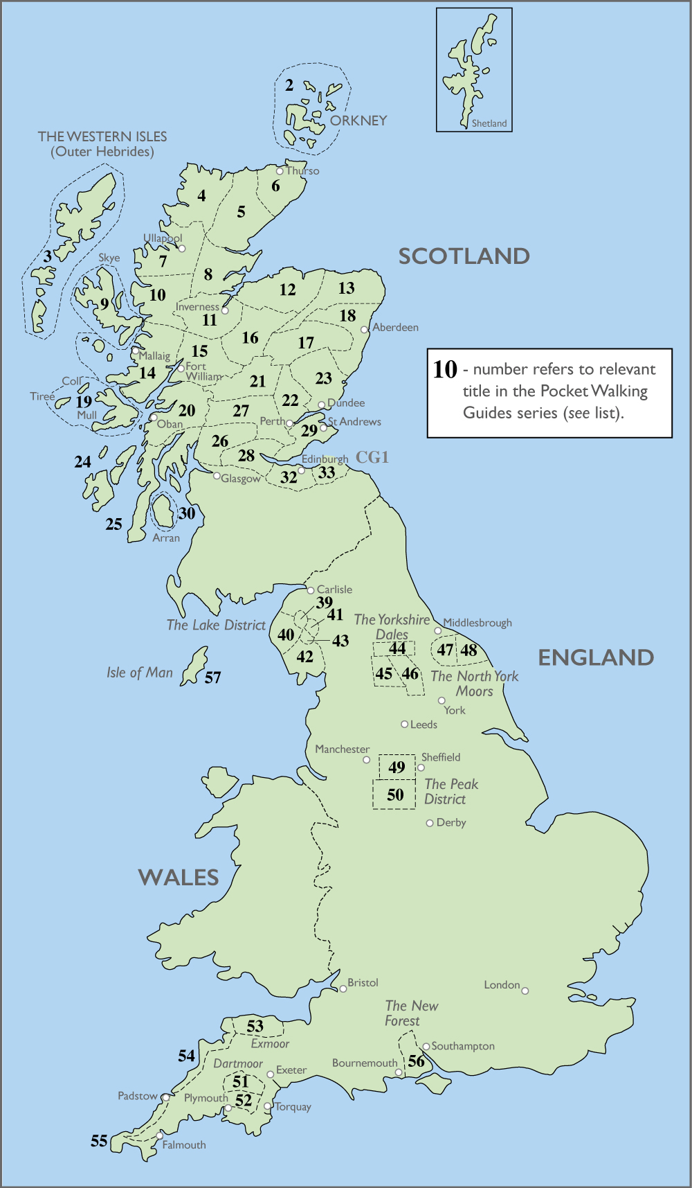
Another resource I have found handy (although not for wall maps) is a series of books Halliwell Pocket Walking Guides by Paul Williams - their website is at www.pocketwalks.com but they are also available on Amazon.
They are small pocket-sized books and each is dedicated to specific area of Scotland and details 20 or more hikes and walks in that area. There are about 30 books in the series covering the Highlands and Islands, plus a few more for parts of England - see image below form their website:
-
The Following 2 Users say 'Aye' to Tomo For This Useful Post:
-
8th September 21, 05:25 AM
#6
Originally Posted by Tomo
Another resource I have found handy (although not for wall maps) is a series of books Halliwell Pocket Walking Guides by Paul Williams - their website is at www.pocketwalks.com but they are also available on Amazon.
They are small pocket-sized books and each is dedicated to specific area of Scotland and details 20 or more hikes and walks in that area. There are about 30 books in the series covering the Highlands and Islands, plus a few more for parts of England - see image below form their website:
Thanks for this. My daughter moved to Edinburgh this week for school so I'm going to get one of these for her to get to know the area.
-
-
10th September 21, 02:50 AM
#7
If vintage maps appeal, Bartholomew's New Reduced Survey at half-inch to the mile for cyclists and tourists are superb.
Scotland is devided up into a series of 29 sheets, and are available as paper mounted on cloth - and the detail is excellent.
These date from about 100 years ago, and versions remained in print until fairly recently. The pre-war issue show all kinds of things that no longer exist - the now-gone railways, steamer routes, etc - are coloured to show contours, and are a reasonable size to frame and hang on the wall.
The Ordnance Survey Quarter Inch fifth series from the 1970s are larger sheets, and show greater area, and are equally decorative. Sheet 5 of the Eastern Highlands covers an area from the Firth of Tay to the Cromarty Firth, and from Fort Augustus to the east coast, so includes the Grampians, Speyside, Royal Deeside, etc. Eight maps in this series covers the whole of Scotland and the Islands.
For the most up-to-date maps for motoring or walking, any of the current Road Map, Landranger or Explorer series of increasing scale are the best you can get. You can use the OS website to customise maps in various ways - https://shop.ordnancesurvey.co.uk/maps/ - including placing a significant site (your own home, for example) at the centre of the map you have printed.
-
The Following User Says 'Aye' to Troglodyte For This Useful Post:
-
10th September 21, 03:57 AM
#8
Not sure if this is too big for your needs (36" x 45"): https://www.mapmarketing.com/product...nated-wall-map
-
-
13th September 21, 09:13 AM
#9
If you want something a little different and funny, check out ST&Gs marvellous map of great British place names.
-
-
13th September 21, 11:17 AM
#10
Agree, the Ordnance Survey maps are great. I bought a 2007 edition of Great Britain labeled, "For National Route Planning."
Ol' Macdonald himself, a proud son of Skye and Cape Breton Island
Lifetime Member STA. Two time winner of Utilikiltarian of the Month.
"I'll have a kilt please, a nice hand sewn tartan, 16 ounce Strome. Oh, and a sporran on the side, with a strap please."
-
Tags for this Thread
 Posting Permissions
- You may not post new threads
- You may not post replies
- You may not post attachments
- You may not edit your posts
-
Forum Rules
|
|


Bookmarks